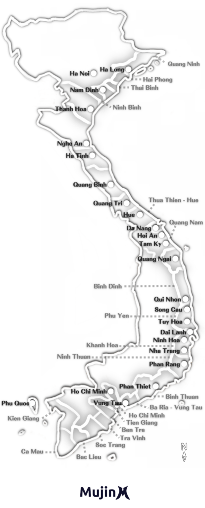

ベトナムで良い波を当てるためには波と風情報の収集が欠かせません。潮見表も重要です。そこでベトナムで最も使える波情報サイト Surf-forecast と風情報サイト Windy を活用しやすいように北の地域から順に並べました。サーフトリップや日頃の波予測にブックマークしてお役立てください。
目次
Windy 風情報と風予測
Surf-forecast 波情報と波予測
※スマートフォンでは表が切れて表示されます。
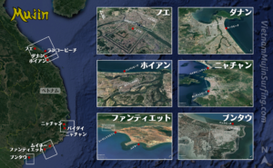
北のポイントから順に並べました
1 フエ ランコービーチ
フエ ランコービーチ波予測詳細
Lang Co 48 hour detailed Surf Forecast
Lang Co surf forecast – detailed table of surfing conditions for Lang Co for the next 2 days, with swell components, wave heights, wave energy, wave periods, La…
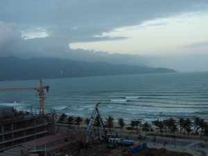
2 ダナン ミーケビーチ
View detailed surf forecast for My Khe / Da Nang. Visit surf-forecast.com for more details, long range forecasts, surf reports, swell and weather maps.
ダナン ミーケビーチ波予測詳細
My Khe / Da Nang 48 hour detailed Surf Forecast
My Khe / Da Nang surf forecast – detailed table of surfing conditions for My Khe / Da Nang for the next 2 days, with swell components, wave heights, wave energy…
3 ホイアン クーダイビーチ
View detailed surf forecast for Cue Dai Beach. Visit surf-forecast.com for more details, long range forecasts, surf reports, swell and weather maps.
ホイアン クーダイビーチ波予測詳細
Cue Dai Beach 48 hour detailed Surf Forecast
Cue Dai Beach surf forecast – detailed table of surfing conditions for Cue Dai Beach for the next 2 days, with swell components, wave heights, wave energy, wave…
4 ニャチャン バイダイニャチャン
View detailed surf forecast for Bai Dai Nha Trang. Visit surf-forecast.com for more details, long range forecasts, surf reports, swell and weather maps.
ニャチャン バイダイニャチャン波予測詳細
Bai Dai Nha Trang 48 hour detailed Surf Forecast
Bai Dai Nha Trang surf forecast – detailed table of surfing conditions for Bai Dai Nha Trang for the next 2 days, with swell components, wave heights, wave ener…
5 ファンティエット ムイネー
ファンティエット ムイネー波予測詳細
Mui Ne 48 hour detailed Surf Forecast
Mui Ne surf forecast – detailed table of surfing conditions for Mui Ne for the next 2 days, with swell components, wave heights, wave energy, wave periods, Mui …
6 ブンタウ バックビーチ
ブンタウ バックビーチ波予測詳細
Vung Tau (Back Beach) 48 hour detailed Surf Forecast
Vung Tau (Back Beach) surf forecast – detailed table of surfing conditions for Vung Tau (Back Beach) for the next 2 days, with swell components, wave heights, w…
上記6つのサーフポイント位置情報
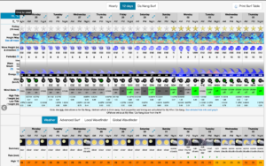
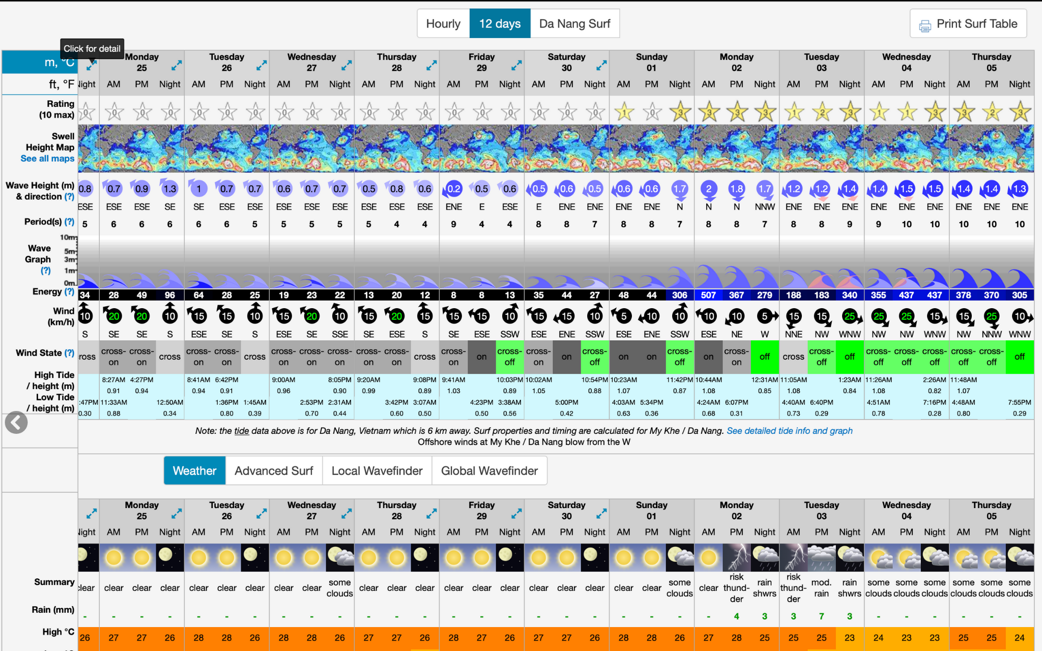
Surf-forecast の見方
上に設置した Surf-forecast 波予測表のみかた
| 英語表記 | 日本語訳 | 説明 |
|---|---|---|
| Date | 曜日と日付 | 曜日、日月の順で記載。直近48時間分の閲覧が可能。 |
| Time | 時間 | 3時間毎の表示。日差しがある時は10AMごろにオンショアが強くなり始める事が多い。1PMまで風が弱い日は終日サーフできる日が多い。 |
| Rating | 波質の評価 | 10段階評価。波無しまたはオンショアだと評価無し。参考までに、1つ星で小波サーフ可、2つか3つ星で一般的な良い波、4つ星以上はオフショアだけどサイズも大きくなるので注意。 |
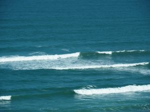
| Wave Height | 波の高さ | 参考値は、0.5mで膝腰、1mで腹胸、1.5mで肩頭、2mでオーバーヘッドくらい。1.5mを超えるとリーフブレイクが割れ始める。 |
| Wave Direction | 波の向かう方向 | 夏は南西寄りから来る波、冬は北東寄りから来る波が多い。海岸または岩場の地形に対して、斜めから入ってくる波は形良い波になりやすい。真正面から入るとダンパー気味になりやすい。地形は直線よりも、カーブしている方が波の崩れ方が順序よく遅くなりやすい。 |
| Wave Period | 波の周期波長リズム | 8以下はライディング距離は短く力の弱い波。9〜11くらいは普通くらい。12以上はロングライドができ、フェイスが広く力が有り、セット間は長く、波質が良くなる傾向。波長が短いほど波と波の間が詰まったオンショア波のようになり、重なりダブる波も出てくる。 |
| Wind Speed & Direction | 風向きと強さ | 風速10km/h以下だと風は弱く波のフェイスは綺麗。風速15km/hのオンショアだとフェイスが乱れ始める。風速20km/hだとやや強い風に感じ、オンショアだと海面はグチャグチャになる。風速25km/h以上だと強風に感じ、風向きに関係なく波乗りに悪影響が出るが、ストレートオフショアに限ってはチューブになり好影響の事もあり得る。 |
| Wind State | 海岸線と風向きの関係 | glass 無風または off オフショアが最も良い。また風は弱ければ弱いほど良い。cross-off はサイドオフショアで、風速10km/h以下の弱い風なら問題無い。cross サイド、cross-on サイドオン、on オンショアの波は良く無いけれど、これも風速10km/h以下なら海面は綺麗な事が多く問題無い。 |
| Weather | 天気 | 3時間毎の天気予報。 |
| Air temp | 気温 | 3時間毎の外気温予想。 |
このほか、Surf-forecast サイト上には2つの重要な情報が掲載されています。1つは波の力やサイズ指標になる波のエネルギー数値。もう1つは潮見表です。更に、7日から12日先までの波予測が見れます。数日先までは1時間単位での波予測も見れます。
Surf-forecast サイト上で見る波予測詳細の見方とポイント